Article

Macro-Habitat Suitability for Threespine Stickleback (Gasterosteus aculeatus L.) Near the Southern Limit of Its Global Distribution: Implications for Species Management and Conservation

1
MARE-Centro de Ciências do Mar e do Ambiente, ARNET-Rede de Investigação Aquática, Universidade de Évora, Largo dos Colegiais 2, 7004-516 Évora, Portugal
2
Departamento de Biologia, Escola de Ciências e Tecnologia, Universidade de Évora, Largo dos Colegiais 2, 7004-516 Évora, Portugal
*
Author to whom correspondence should be addressed.
Fishes 2022, 7(5), 271; https://doi.org/10.3390/fishes7050271
Submission received: 5 September 2022 / Revised: 25 September 2022 / Accepted: 26 September 2022 / Published: 2 October 2022
(This article belongs to the Special Issue Advances in Endangered Aquatic Animals Protection)

Abstract

:
The threespine stickleback is a freshwater fish listed as endangered in Portugal, near the southern limit of the species global distribution. However, few measures have been proposed aiming at the conservation of this species in suboptimal environments. From existing databases and specific sampling campaigns, we obtained occurrence data of threespine stickleback for a total of 646 sites. The occurrence data, together with 15 environmental macrohabitat predictors, were used to model the potential distribution of the species using an ensemble of species distribution models. Through the results of our final ensemble, we project that the threespine stickleback occurs predominantly at lower stretches of river systems, where sandy substrate is dominant and flow is higher. Within this region, sticklebacks are also more likely to occur in sites with high levels of rainfall in the driest month, thus avoiding locations with high potential for drying during summer. The species also tends to avoid steep slope areas with high levels of annual precipitation. Based on our results, a map of the species probability of occurrence was generated and river sections were categorized into levels according to their importance for the species’ conservation.

1. Introduction

The threespine stickleback (Gasterosteus aculeatus L.), a native species from Portugal, is a small teleost fish that occurs in almost the entire northern hemisphere, presenting its southern limit of distribution in the Mediterranean region, where the local environmental conditions are harsh and suboptimal to the species’ preferences [1,2,3,4,5,6]. This species is characterized by a complex of phenotypically different populations, including strictly marine or freshwater populations as well as anadromous ones. These result from its different adaptations to the different types of habitats, but despite that, all individuals captured until now, in the Iberian Peninsula, had freshwater phenotypic characteristics [1,3,7,8].
The conservation of biodiversity requires reliable information on species distribution and habitat use, especially when dealing with populations that are located near the limits of the species’ global distribution, usually in harsh and less than optimal environmental conditions. Our study was carried out in mainland Portugal, which represents the southern limit of the threespine stickleback Atlantic distribution and where the threespine stickleback is classified as endangered (EN) [2]. The conservation of native species that are close to their distribution limits is very important because these species already live close to their tolerance limits, and even small environmental changes, such as the ones happening in the current global warming scenario, can easily lead to the decline of their populations [9,10,11,12].
Although the habitat preferences of sticklebacks, on a micro- and meso-habitat scale, are largely known, there are no studies aiming to know the regional (macroscale), environmental variables that influence the species distribution [1,9,10,13]. Previous research has shown that large-scale geomorphic variables (e.g., channel elevation, altitude and slope) can be used as reliable predictors of the occurrence of fish species and their responses to habitat characteristics, as well as for identifying atypical populations [14,15,16]. Since it is difficult, these macro-habitat predictors could be useful to integrate in management and conservation programs directed to these species and their habitats [17,18,19].
So, considering the existing knowledge gaps about G. aculeatus, this study aims to identify which macro-scale environmental factors determine regional distribution of G. aculeatus, using species distribution models (SDM) to predict their potential distribution [20,21,22]. Ultimately, this information will contribute to the conservation of the threespine stickleback populations in mainland Portugal through the identification of the areas with the most suitable habitat for the target species. More specifically, we aim to (i) identify the occurrence sites of this species in the study area and characterize its distribution; (ii) identify the macro-scale environmental factors that determine their distribution near the southern limit of the species distribution; (iii) develop a regional predictive model of occurrence probability for the threespine stickleback; and, based on these results, (iv) identify important areas for species conservation.

2. Materials and Methods

2.1. Study Area

This study was performed in mainland Portugal, which comprises an area of approximately 89 015 km², and is located at the western end of the Iberian Peninsula, where most regions face a typical Mediterranean climate characterized by cool, wet winters and hot dry summers. Seasonality and variability in rainfall are the main attributes of the Mediterranean-type climate, with the annual mean temperature, in mainland Portugal being 15.6 °C (±4.7 °C) and the annual mean precipitation 834 mm (±211 mm) [23,24,25]. Most land use in mainland Portugal is associated with agriculture (39.7%) and natural or semi-natural forests (37.8%) [26].

2.2. Species Occurrence Data

The G. aculeatus occurrence data in mainland Portugal were obtained from existing databases (i.e., previous projects of the research team responsible for this study, combined with official data from national authorities, such as ICNF–Institute for Nature Conservation and Forests). The data collected were verified for geographic coordinate errors and duplicate records were removed. Furthermore, only data from 2010 onwards were used as we considered previous data was outdated and would need in situ verification, which was not feasible. Data were completed with sampling campaigns, carried out between April and October of 2019, specifically designed to fill geographical gaps in the data from Portuguese river basins. Sticklebacks were sampled using electrofishing (Hans Grassl ELT 60 II-HI 500 V-DC, Schönau am Königssee, Germany), following the standard sampling protocol defined by national authorities in the scope of Water Framework Directive (WFD) [27].

2.3. Environmental Predictors

The environmental variables used to predict the distribution of G. aculeatus were chosen based on their ecological relevance in the macro-scale distribution of other freshwater fish species [16]. Initially, 17 variables were selected according to their typology: geomorphology, climate, environmental stressors and hydrology (Table 1).
The environmental variables of geomorphological typology used in this analysis were: altitude, river slope, distance to coast and the type of substrate (percentage of silt and percentage of sand in the soil). Altitude (“altitude”) was obtained from WorldClim version 2.1, with a resolution of 1 km², while both slope and distance to coast were calculated using the SRTM Digital Elevation Model in ArcGIS [28,29]. Distance to coast (“dist_coast”) was included as it reflects the changes in physical and chemical characteristics of the rivers from the headwaters to downstream extent [30]. The type of substrate was recognized as an important factor limiting the distribution of G. aculeatus because it is often used as refuge by the studied species [31]. Two types of substrates were used in our analysis: percentage of silt (“silt”, grain size between 0.002 and 0.063 mm) and percentage of sand (“sand”, grain size between 0.063 and 2 mm). These data were obtained from the Harmonized World Soil Database (1 km²/resolution) [32].
Since the habitat structure is defined largely by physical processes, especially by the movement of water, and in some Mediterranean rivers, the flow variation is very important for the distribution of fish species due to the temporary regime of several watercourses, some hydrology predictors were added to our species distribution model [16,33,34]. Thus, flow in target locations was estimated using two flow accumulation functions in ArcGIS and two flow indexes in Saga [35]. The flow accumulation (“f_accum”) function corresponds simply to the total area that drains to each location, while flow (“f_weight_rain”) was calculated using the flow accumulation weighted by the mean annual precipitation. The SAGA Topographic Wetness Index (“TWI”) and the Stream Power Index (“SPI”) are measures of the wetness and the erosive power of flowing river water, respectively [36,37].
Temperature and precipitation are variables that also influence the distribution of freshwater species as they directly correlate with water temperature and amount of water received in the river basins [38,39]. To characterize Portuguese climate, four climate predictors were included in our analyses: annual mean temperature (“tempmean”), maximum temperature of the warmest month (“tempmax”), annual precipitation (“precip”) and precipitation of the driest month (“precipdriest”). All climatic predictors were obtained from WorlClim version 2.1 database, at a 1 km² cell resolution [28].
One of the biggest threats to the freshwater ecosystem is pollution from human activities such as industrial effluents, agricultural activities, urban waste management issues and the increase in urbanized areas [12,40]. Since there are no databases with sufficient information on all polluting sources in mainland Portugal, and assuming that water quality is associated with uses of drained soil, we used Corine Land Cover 2000 land use data as a proxy for water quality (100 m²/resolution) [41,42]. Land uses were divided into three types: (1) artificial surfaces (“use_art”), (2) agricultural uses (“use_agr”) and (3) forest and semi-natural areas (“use_forest”). Another environmental stressor included in our study was demographic information (“populat”, total population) that was obtained from LandScan (1 km²/resolution) and used as an indicator of the organic pollution level from domestic effluents [43].
Collinearity between variables was accessed using VIF (variance inflation factor), a method used to measure how strongly each predictor can be explained by the rest of predictors [44,45]. “Annual average temperature” and the “forest and semi-natural areas” variables were removed from the analyses because VIF values exceeded the defined threshold (10) and could lead to an increase of model error and uncertainty [20,46,47]. Therefore, only 15 environmental variables were used in following analyses, but as the removed variables were highly correlated with some of the remaining predictors, no environmental information was lost.

2.4. Statistical Modeling

To reduce the uncertainty associated with SDM, we implemented an ensemble forecasting method that combined the weighted projections of all statistical models used and is reported to outperform the predictions of individual statistical models [48,49,50]. Nineteen different statistical models were available and, for each model, optimal parameterization and fit evaluation were conducted using the True Skill Statistic (TSS) threshold and models performing worst (with TSS values < 0.6) were excluded from the final ensemble [51,52].
The final ensemble included 10 of 19 statistical techniques available: generalized linear model (Glm), random forest (Rf), flexible and discriminant analysis (Fda), multiple discriminant analysis (Mda), model occurrence probability using presence-only data (Maxlike), lasso and elastic-net regularized generalized linear models (Glmnet), multivariate adaptive regression splines (Mars), boost regression trees (Brt), recursive partitioning and regression trees (Rpart) and maximum entropy (Maxent).
All models were calibrated using 70% of random occurrence data, and the performance of each model was evaluated against the remaining 30% of the data [49,53]. Beyond creating independent or at least partially independent sets for model calibration and validation, partition also allows us to take data uncertainty into account [54]. The procedure was repeated 50 times and final ensemble was built using 100% of the data as data partitions have been shown to add significant uncertainty to forecasts [48]. Data processing was performed using SDM package [44] in R program (R Development Core Team, 2010, Auckland, New Zealand) version 3.2.2.

2.5. Definition of Conservation Priorities

The map with the probabilities of occurrence of the target species, obtained through our ensemble forecasting model and of the confirmed occurrences of G. aculeatus in mainland Portugal, were used to define the classification of river stretches in four levels of importance for the conservation of this species, being:
  • Level 0 (no conservation interest): River stretches belonging to watersheds where G. aculeatus presence was not confirmed. This level was also assigned to river stretches with absence of the species and with an occurrence probability of less than 20% but belonging to watersheds in which, in other river stretches, the presence of the species has already been confirmed.
  • Level 1 (moderate importance for conservation): River stretches with the absence of the species and where the probability of occurrence ranges between 20% and 40% but belonging to watersheds that cover other river stretches in which the presence of the species has already been confirmed.
  • Level 2 (high importance for conservation): River stretches with the absence of the species and where the probability of occurrence is above to 40% but belonging to watersheds that cover other river stretches in which the presence of the species has already been confirmed.
  • Level 3 (maximum importance for conservation): River stretches with confirmed presence of G. aculeatus and stretches upstream and downstream of the presence with a probability of occurrence greater than 10%.
Some of the confirmed presences of threespine stickleback occurred at isolated sites, surrounded by low or null probability areas. As these isolated populations are of the uttermost importance for species conservation, and defined protection sites would be poorly effective, we opted for a conservative approach to the protection of the species. We assigned the maximum importance level of conservation not only to the isolated population area but also to the adjacent river stretches to prevent the fragmentation of species habitat since river connectivity is essential for species viability and for maintaining their population structure [55]. The maximum importance level of conservation, in adjacent river stretches to places with the presence of the species, excluded places where the probability of occurrence is less than 10% as they are considered suboptimal for the survival of the species.
Additionally, the waterlines that maintain connectivity between sites with presence of G. aculeatus and the ocean have been highlighted as sections where particular attention should be given to ensure the maintenance of longitudinal connectivity due to the probability, not yet confirmed for Portugal, that this species can develop an anadromous form [2]. Since the definition of several levels of conservation interest for small water courses close to each other would be impractical and ineffective, when the same water line has different probabilities of occurrence, the interest level assigned corresponds to the level that has the greatest extension in that waterline. Existing reservoirs were superimposed onto our probability map and defined, through expert judgement, as sites with no interest for this species due to their abiotic and biologic characteristics (e.g., dominance of non-indigenous piscivorous fish).

3. Results

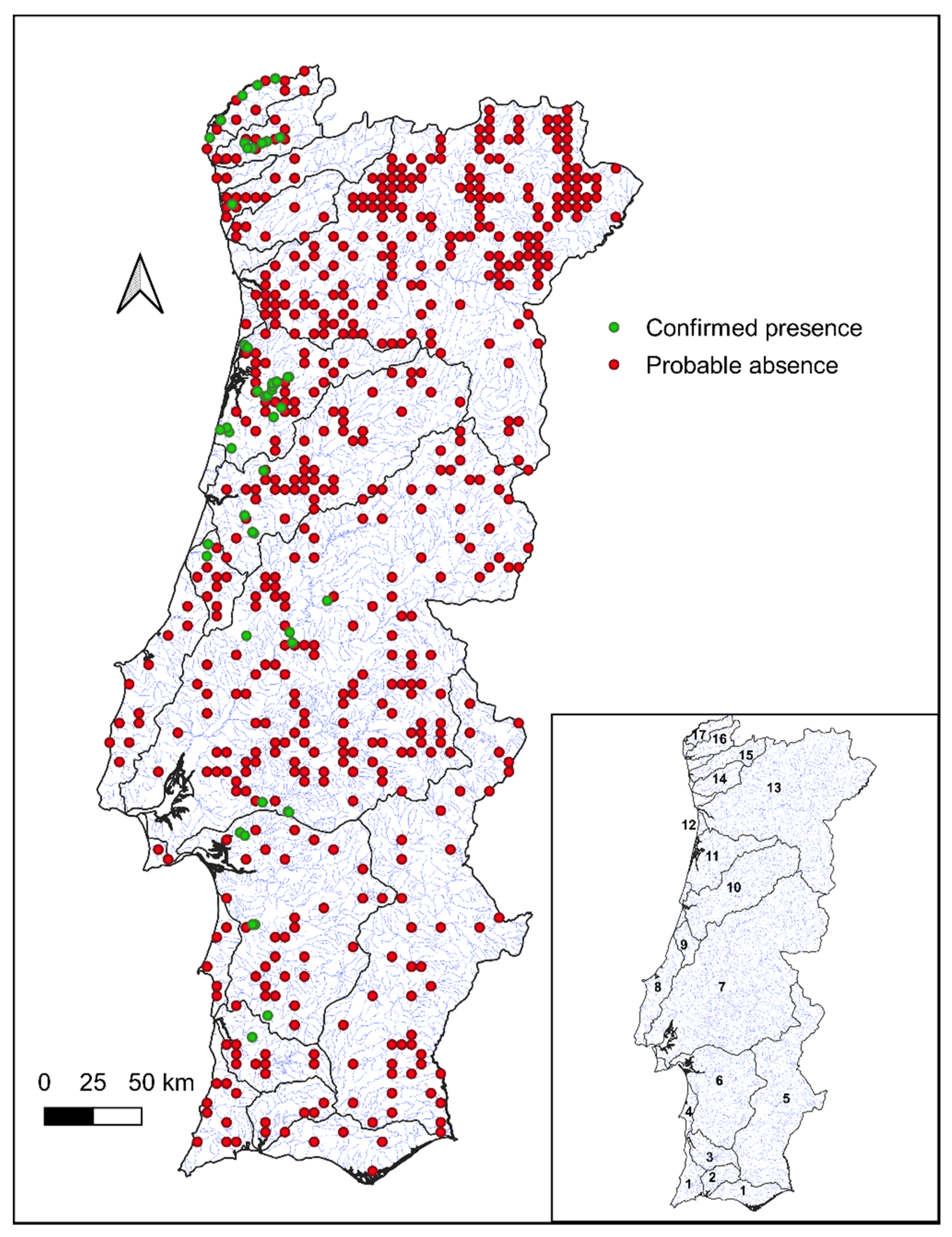
3.1. Distribution of G. aculeatus

Data from databases and sampling campaigns comprised our final dataset with 646 points. However, the presence of threespine stickleback was detected only at 7.9% (presence = 51) of the total sites and was mainly observed close to the Portuguese coast (Figure 1). A wider distribution of stickleback was observed in the Vouga River basin, where about 37% of the species overall presence was found.

3.2. Relationship between G. aculeatus Occurrence and Environmental Predictors

According to our final ensemble results, occurrence of G. aculeatus is manly influenced by the macro-habitat variables “slope”, “precipdrie”, “precip”, “sand”, “f_weight_rain” and “f_accum”, with contribution values of 49.5%, 23.9%, 15.5%, 9.5%, 8.4% and 6.6%, respectively. The selected set of environmental variables and the selection of models with TSS values greater than 0.6 allowed the development of a final ensemble with a very good performance, with a mean TSS of 0.68 (±0.05).
According to the response curves of the target species occurrence with the variation of the most important predictors (Figure 2), we can conclude that the threespine stickleback presence is mostly associated with river segments combining slopes lower than 15° and with the predominance of sandy substrates. The occurrence of this species is also associated with habitats with low values of average annual precipitation but with high values of precipitation in the driest month, occurring mainly in areas where these variable values are around 20 and 30 mm, respectively. The response curves also demonstrate a preference of the species for sites with running water but not necessarily for rivers with larger drainage areas, which reflects a dependence of the species from the local climate, especially concerning water availability.

3.3. Spatial Predictions of G. aculeatus Probability of Occurrence

The values of probability of occurrence for G. aculeatus, predicted for mainland Portugal, according to our model, range from 0% to ca. 56% (Figure 3). The highest values of occurrence probability were found in the northern region of mainland Portugal, near the coast, in the Minho, Lima and Vouga River basins, while the lowest values were found in the east zone of the country, close to the border with Spain, and in the south, specifically in the Algarve region, where the probability of occurrence values rarely exceeded 0%. The probability of occurrence was also moderately high (between 30% and 40%) in some watercourses located in watersheds where the species was not detected, for example in the Neiva and Ave River basins.

3.4. Map of Conservation Priorities

In total, the different importance levels of conservation were assigned to about 1021 km of river sections, being the maximum level, the one that covered a greater number of kilometers (540 km) (Table 2), followed by the moderate importance level (313 km) and, finally, the high importance level (48 km) (Figure 4). Due to the possible existence of the anadromous form of threespine stickleback, about 120 km of important river sections for the maintenance of longitudinal connectivity with the sea have been identified. At least one of the importance levels for conservation has been assigned to almost all major river basins, except for the Douro, Guadiana and Ave River basins and also except for some of the smaller independent streams that exist along the country’s littoral region, namely the Algarve, North and West Streams.

4. Discussion

4.1. Influence of Environmental Variables on the Distribution of G. aculeatus

The large survey conducted for this study demonstrated that in mainland Portugal, the areas with the highest probability of occurrence were found close to the coast (less than 40 km from the sea), from the central area of Portugal, in the Mondego River basin, to the far north of the country, specifically on the Minho River. With increasing distance to the coast, the probability of occurrence of the species decreased considerably. The areas with the lowest probability of occurrence were, in most cases, as we expected, those for which there are no detections of the species presence, such as the Guadiana River basin and Algarve Streams. Lentic water ecosystems, as the reservoirs that we can find, for example, in the Douro basin, associated with the construction of dams and similar impassable structures, were considered by expert judgement as places with no conducive conditions to the occurrence of sticklebacks and defined as sites of null probability of occurrence, because they have, among other characteristics, low and highly fluctuating levels of oxygen, which are not suitable to the development of their eggs and juveniles [10]. Furthermore, these habitats with lentic characteristics are usually dominated by invasive species that compete for resources and space with sticklebacks and even predate our target species.
Our study showed that the distribution of the threespine stickleback in the study area is explained mainly by six macroscale environmental variables (Appendix A: Figure A1): “slope”, “percentage of sand”, “precipitation of driest month”, “annual precipitation”, “flow accumulation” and “flow”.
“Slope” is the strongest predictor for the distribution of G. aculeatus in the study area. The peak probability of occurrence of this species occurs at very low slope values, found mostly in river stretches near the coast, and begins to decrease in areas with slope higher than 15°, with the probability of occurrence of 0% in the mountainous areas of mainland Portugal. “Slope” is a variable with an indirect effect on species distribution as it influences other variables, such as annual mean temperature, water flow, granulometric composition and, mainly, because it is related to altitude [56,57]. With the increase in the slope, there is a decrease in the “annual mean temperature” (a variable that was removed from our analyses because it was highly correlated with the slope) and, consequently, in the water temperature of rivers [38]. Water temperature is a determining factor in the distribution of fish species due to its influence in spawning periods and in the growth and mortality rates [58]. Knowing that most sticklebacks fail to reach sexual maturity when exposed to temperatures below 10°C, we expected that this species will tend to avoid river stretches with low water temperatures associated with steep slopes and high altitudes [5,59,60].
The slope of the river channel has a vital role also in streamflow and in the water accumulated by the basins, determining the hydrologic and geomorphologic characteristics of the river [61,62,63,64]. In our final ensemble model, two variables related to the river flow had an important influence in the distribution and occurrence of G. aculeatus, these being the flow (“f_wheight_rain”) and flow accumulation (“f_accum”). However, as we concluded from our analyses (cf. Figure 2), the amount of water that the basin receives from precipitation (“f_weight_rain”) had more influence on the distribution of sticklebacks in Portugal than the dimension of the drainage basin. The increase in the probability of occurrence of this species with the increase of flow (“f_weight_rain”) and with the increase of the “precipitation in the driest month”, which is also one of the variables with higher influence in the distribution of G. aculeatus, is an indicator that the species avoids rivers with temporary regimes, which is a highly important feature for populations of this species inhabiting southern Mediterranean areas [65]. Even if these temporary rivers, with typically Mediterranean characteristics and mainly found in the south of Portugal, have large drainage basins, they are not favorable to the occurrence and survival of G. aculeatus due to the severe variation and reduction in the amount of water and the consequent degradation of aquatic habitat in the driest months [6,9,10]. The few isolated populations of the target species that were found and persist in this type of temporary habitat (e.g., Sado and Mira basins) have probably developed adaptations to survive in these adverse and suboptimal conditions [5,6,7]. Although this species tends to avoid temporary rivers, it also tends to avoid rivers with large drainage basins that can accumulate too much water from high levels of “annual precipitation” and even too high levels of “f_weight_rain”. In rivers with these characteristics, mainly in steep channel slopes, the effects of flash floods associated with this large amount of water are more intense, and the current velocity is higher, making nest building more difficult and potentially causing higher mortality and displacement of individuals since sticklebacks have poor swimming capability [66,67]. In addition, habitats with these characteristics require greater energy expenditure by aquatic organisms, and sticklebacks need to save this energy for nest building and parental care [13,68].
The fact that the slope influences the water flow means that it indirectly also influences the type of sediment and substrate of the river. From our results, we observed that the percentage of sand is also one of the factors that most influences the distribution of the threespine stickleback in the study area, corroborating other studies where individuals of this species were captured in habitats constituted mostly by sand and gravel [9]. The probability of occurrence of G. aculeatus increases with increasing percentage of sand, probably because this small substrate is easy to dig, being then used by sticklebacks to build nests and as a refuge in the presence of predators [9,13].

4.2. Prioritizing Conservation of G. aculeatus

To protect this species, we recommend a set of regional conservation measures based on our map of conservation priorities since most of the confirmed occurrences and the places with the highest probability of occurrence are not covered by any type of legal protection, e.g., the National Network of Protected Areas of Portugal [69].
The isolated populations residing in river stretches surrounded by low or null probability areas, as observed in the Sado and Mira river basins and in some tributaries of the Tagus river (streams with typical Mediterranean characteristics), although probably having developed adaptations to survive the harsh environment observed in such rivers during the summer, are still less likely to persist because they face greater risk of extinction through demographic and environmental stochasticity and Allee effects and are less likely to be recolonized through dispersal from neighboring populations [17]. Therefore, as these populations may represent alternative strategies and genetic profiles distinct from all other populations in the world, they should be effectively protected to conserve the evolutionary heritage of the stickleback adaptive radiation [6,7,10,12]. Additionally, despite the attempt to cover all the geographic area of mainland Portugal, it is possible that we did not capture all the environmental space where the species occurs, so the final model might underestimate the probability of occurrence in these areas [70].
The fact that the maximum level of interest for conservation of this species has been assigned to river stretches with confirmed presence of G. aculeatus and to the surrounded stretches to maintain the connectivity of the waterlines represents a conservative approach for the problem of isolated populations. Moreover, the high and moderate interest levels for conservation of sticklebacks were created to categorize rivers that have no confirmed presence but that have environmental characteristics capable of supporting the existence of stickleback populations, thus being the first rivers to be repopulated if necessary. Additionally, as environmental conditions are expected to vary due to climate change, these areas might become important refuges in future scenarios.
The anadromous form of the threespine stickleback is thought to occur in Portugal, although its presence was never confirmed, which is probably related with the lack of studies directed to this objective with an adequate selection of sampling areas (e.g., downstream brackish sections of main rivers and respective tributaries, coastal lagoons) and methods (e.g., minnow traps, hand nets) [71,72]. Nevertheless, in this study we decided to highlight the river stretches that are important for the maintenance of connectivity with the sea because, independently of the presence or absence of the anadromous stickleback form in Portuguese river basins, the maintenance of longitudinal connectivity between freshwater and marine habitats will always improve the conservation of aquatic ecosystem in general, helping the migration and completion of the life cycle of other endangered diadromous species that share similar distribution areas with G. aculeatus, such as the anadromous river lamprey (Lamprey fluviatilis L.), in the Tagus river, or allis shad (Alosa alosa L.), the sea trout (Salmo trutta L.) and the Atlantic salmon (Salmo salar L.) in the northern and central river basins of Portugal [16,68,70,71,72,73].
Although the results obtained in this study can be used as per the definition of conservation measures for this species, it is necessary to consider the possibility of carrying out further studies in the future to corroborate these results. The fishing data are subject to several sources of uncertainty, since not capturing individuals in one location does not mean that the species does not exist in that site, so our study may have underestimated the presence data, distorting our results. In addition, sometimes there may be undeclared catches, uncertainty in species identification and incorrect use of capture techniques due to a lack of knowledge of species ecology, among others. As much as these sources of uncertainty have been reduced, the difference in the amount of data between presences and absences of the species was high, so the area where the probability of occurrence is very low may have been overestimated. In addition to the uncertainties associated with occurrence data, sometimes the lack of more recent information for some environmental variables can also cause a slight bias in results, such as the lack of more recent data for land use. As well as the uncertainty associated with the statistical models used in the ensemble forecast, to implement more effective conservation measures for the designated rivers, it becomes necessary to add to the analysis more detailed and local variables that can affect the species in these specific habitats, such as, for example, micro- and meso-habitat (e.g., temperature, salinity, dissolved oxygen, substrate, depth, current velocity, refuges) and fish assemblage (e.g., presence of stickleback competitors or predators, non-native species) characteristics. Future efforts should focus on addressing these topics to improve the projections of species distribution models, with the aim of corroborating and even improving the conclusions obtained in this study.

5. Conclusions

Despite wide geographical distribution, evolutionary history and high genetic, morphological and behavioral diversity, G. aculeatus populations are declining due to threats such as the introduction of non-native species, pollution and human activities [1,2,7,8,10,12]. This critical situation is more relevant and worthy of additional concern for species populations inhabiting regions located near the southern limit of its global distribution, in which suboptimal environmental conditions are exacerbated by the Mediterranean climate, with accentuated changes between dry and wet periods with unpredictable flash floods and droughts [23]. Since the lack of knowledge regarding the distribution and ecological requirements of the species, especially in southern European regions, has been an obstacle to the definition of effective conservation measures for G. aculeatus, the information obtained in this study makes it possible to properly address this issue and define hot spots for the conservation of the threespine sticklebacks in Portugal.

Author Contributions

Conceptualization, A.M., C.M.A., P.R.A.; methodology, A.M., C.M.A., J.B.-P.; software, A.M., J.B.-P.; formal analysis, A.M., C.M.A., J.B.-P.; investigation, A.M., C.M.A., J.B.-P., P.R.A., S.S.; data curation, A.M., C.M.A., J.B.-P., S.S.; writing—original draft preparation, A.M.; writing—review and editing, C.M.A., J.B.-P., P.R.A., S.S.; supervision, C.M.A., P.R.A.; project administration, C.M.A., P.R.A.; funding acquisition, C.M.A., P.R.A.; All authors have read and agreed to the published version of the manuscript.

Funding

The sampling campaigns were carried out within the scope of the PADM LV project funded by FCiências.ID. Support was provided by the Portuguese Science Foundation (FCT) through the strategy plan for MARE (Marine and Environmental Sciences Centre) via project UIDB/04292/2020 and under the project LA/P/0069/2020 granted to the Associate Laboratory ARNET. FCT also supported this study through the individual contract attributed to Carlos M. Alexandre within the project CEECIND/02265/2018 and the PhD scholarship attributed to Sara Silva (2021.05558.BD).

Institutional Review Board Statement

Not applicable.

Data Availability Statement

Data are available from the corresponding author upon reasonable request.

Acknowledgments

We would like to thank Ana Rato, Filipa Belo, João Pedro Marques, Roberto Oliveira and Sergio Bedmar for helping with the field sampling campaigns. Thanks are also due to the ICNF for providing some of the occurrence of data used in this study and the fishing permits for sampling purposes.

Conflicts of Interest

The authors declare no conflict of interest. The funders had no role in the design of the study; in the collection, analyses, or interpretation of data; in the writing of the manuscript; or in the decision to publish the results.

Appendix A

Figure A1. Relative importance of each considered environmental variable in explaining the distribution and occurrence of G. aculeatus.
Fishes 07 00271 g0a1

References

  1. Bell, M.A.; Foster, S.A. The Evolutionary Biology of the Threespine Stickleback; Oxford University Press: Oxford, UK, 1994. [Google Scholar]
  2. Cabral, M.J.; Almeida, J.; Almeida, P.R.; Dellinger, T.; Ferrand de Almeida, N.; Oliveira, M.E.; Palmeirim, J.M.; Queiroz, A.M.; Rogado, L.; Santos Reis, M. (Eds.) Livro Vermelho Dos Vertebrados De Portugal: Peixes Dulciaquıícolas E Migradores, Anfíbios, Repteis, Aves E Mamíferos; Instituto da Conservação da Natureza: Lisboa, Portugal, 2005; 660p. [Google Scholar]
  3. Hagen, D.W. Isolating Mechanisms in Threespine Sticklebacks (Gasterosteus). J. Fish. Res. Board Can. 1967, 24, 1637–1692. [Google Scholar] [CrossRef]
  4. Berra, T.M. Freshwater Fish Distribution; Academic Press: Cambridge, MA, USA, 2001. [Google Scholar]
  5. Crivelli, A.J.; Britton, R.H. Life history adaptations of Gasterosteus aculeatus in a Mediterranean wetland. Environ. Biol. Fishes 1987, 18, 109–125. [Google Scholar] [CrossRef]
  6. Rind, K.; Rodriguez-Barucg, Q.; Nicolas, D.; Cucchi, P.; Lignot, J. Morphological and physiological traits of Mediterranean sticklebacks living in the Camargue wetland (Rhone river delta). J. Fish Biol. 2020, 97, 51–63. [Google Scholar] [CrossRef] [PubMed]
  7. Foster, S.A.; Baker, J.A.; Bell, B.A. The case for conserving threespine stickleback populations: Protecting an adaptive radiation. Fisheries 2003, 28, 10–18. [Google Scholar] [CrossRef]
  8. Sanz, N.; Araguas, R.M.; Vidal, O.; Viñas, J. Glacial refuges for three-spined stickleback in the Iberian Peninsula: Mitochondrial DNA phylogeography. Freshw. Biol. 2015, 60, 1794–1809. [Google Scholar] [CrossRef]
  9. Alexandre, C.M.; Almeida, P.R. Summer survival and habitat characteristics of a threespine stickleback (Gasterosteus aculeatus L.) Southern European Population. Limnetica 2009, 28, 125–138. [Google Scholar] [CrossRef]
  10. Clavero, M.; Pou-Rovira, Q.; Zamora, L. Biology and habitat use of three-spined stickleback (Gasterosteus aculeatus) in intermittent Mediterranean streams. Ecol. Freshw. Fish 2009, 18, 550–559. [Google Scholar] [CrossRef]
  11. Normand, S.; Treier, U.A.; Randin, C.; Vittoz, P.; Guisan, A.; Svenning, J.-C. Importance of abiotic stress as a range-limit determinant for European plants: Insights from species responses to climatic gradients. Glob. Ecol. Biogeogr. 2009, 18, 437–449. [Google Scholar] [CrossRef]
  12. Araguas, R.M.; Vidal, O.; Pla, C.; Sanz, N. High genetic diversity of the endangered Iberian three-spined stickleback (Gasterosteus aculeatus) at the Mediterranean edge of its range. Freshw. Biol. 2011, 57, 143–154. [Google Scholar] [CrossRef]
  13. Mayden, R.L.; Page, L.M.; Burr, B.M. A Field Guide to Freshwater Fishes of North America North of Mexico. Copeia 1992, 1992, 920. [Google Scholar] [CrossRef]
  14. Gorman, O.T.; Karr, J.R. Habitat Structure and Stream Fish Communities. Ecology 1978, 59, 507–515. [Google Scholar] [CrossRef]
  15. Lanka, R.P.; Hubert, W.A.; Wesche, T.A. Relations of Geomorphology to Stream Habitat and Trout Standing Stock in Small Rocky Mountain Streams. Trans. Am. Fish. Soc. 1987, 116, 21–28. [Google Scholar] [CrossRef]
  16. Ferreira, A.; Quintella, B.; Maia, C.; Mateus, C.; Alexandre, C.; Capinha, C.; Almeida, P. Influence of macrohabitat preferences on the distribution of European brook and river lampreys: Implications for conservation and management. Biol. Conserv. 2013, 159, 175–186. [Google Scholar] [CrossRef] [Green Version]
  17. Rieman, B.E.; McIntyre, J.D. Occurrence of Bull Trout in Naturally Fragmented Habitat Patches of Varied Size. Trans. Am. Fish. Soc. 1995, 124, 285–296. [Google Scholar] [CrossRef]
  18. Watson, G.; Hillman, T.W. Factors Affecting the Distribution and Abundance of Bull Trout: An Investigation at Hierarchical Scales. North Am. J. Fish. Manag. 1997, 17, 237–252. [Google Scholar] [CrossRef]
  19. Porter, M.S.; Rosenfeld, J.; Parkinson, E.A. Predictive Models of Fish Species Distribution in the Blackwater Drainage, British Columbia. North Am. J. Fish. Manag. 2000, 20, 349–359. [Google Scholar] [CrossRef]
  20. Guisan, A.; Thuiller, W. Predicting species distribution: Offering more than simple habitat models. Ecol. Lett. 2005, 8, 993–1009. [Google Scholar] [CrossRef]
  21. Diniz-Filho, J.A.F.; Bini, L.M.; Rangel, T.F.; Loyola, R.D.; Hof, C.; Noguã©S-Bravo, D.; AraãºJo, M.B. Partitioning and mapping uncertainties in ensembles of forecasts of species turnover under climate change. Ecography 2009, 32, 897–906. [Google Scholar] [CrossRef]
  22. Zhang, X.; Vincent, A.C. Predicting distributions, habitat preferences and associated conservation implications for a genus of rare fishes, seahorses (Hippocampus spp.). Divers. Distrib. 2018, 24, 1005–1017. [Google Scholar] [CrossRef] [Green Version]
  23. Gasith, A.; Resh, V.H. Streams in Mediterranean Climate Regions: Abiotic Influences and Biotic Responses to Predictable Seasonal Events. Annu. Rev. Ecol. Syst. 1999, 30, 51–81. [Google Scholar] [CrossRef]
  24. ICA. Iberian Climate Atlas: Air Temperature and Precipitation (1971–2000); Department of the State Meteorological Agency of Spain, and Portugal, Department of Meteorology and Climatology of the Institute of Meteorology: Madrid, Spain, 2011; 80p. [Google Scholar]
  25. IPMA–Instituto Português do Mar e da Atmosfera. Área Educativa–Clima de Portugal Continental. 2020. Available online: www.portal.pt/pt/educativa/tempo.clima/ (accessed on 16 October 2020).
  26. Central Intelligence Agency, Portugal: The world factbook. Langley, Virginia: Central Intelligence Agency. 2010. Available online: www.cia.gov/library/publications/the-world-factbook/geos/po.html (accessed on 15 October 2020).
  27. Inag, I.P. Manual Para A Avaliação Biológica da Qualidade da Água em Sistemas Fluviais Segundo A Directiva Quadro da Água Protocolo de Amostragem E Análise Para A Fauna Piscícola; Ministério do Ambiente, do Ordenamento do Território e do Desenvolvimento Regional. Instituto da Água, I.P., Instituto da água: Lisbon, Portugal, 2008. [Google Scholar]
  28. Fick, S.E.; Hijmans, R.J. WorldClim 2: New 1-km spatial resolution climate surfaces for global land areas. Int. J. Climatol. 2017, 37, 4302–4315. [Google Scholar] [CrossRef]
  29. ESRI. ArcGIS/ArcInfo for Windows XP. Version 9.3.1; Environmental System Research Institute: Redlands, CA, USA, 2009. [Google Scholar]
  30. Vannote, R.L.; Minshall, G.W.; Cummins, K.W.; Sedell, J.R.; Cushing, C.E. The River Continuum Concept. Can. J. Fish. Aquat. Sci. 1980, 37, 130–137. [Google Scholar] [CrossRef]
  31. Fernández, C.; San Miguel, E.; Amaro, R.; Hermida, M. Espinoso–Gasterosteus aculeatus. In Enciclopedia Virtual De Los Vertebrados Españoles (Virtual Encyclopaedia of Spanish vertebrates); Carrascal, L.M., Salvador, A., Eds.; Museo Nacional de Ciencias Naturales: Madrid, Spain, 2006. [Google Scholar]
  32. FAO/IIASA/ISRIC/ISSCAS/JRC. Harmonized World Soil Database. Version 1.1. FAO: Rome, Italy; IIASA: Laxenburg, Austria, 2009. [Google Scholar]
  33. Poff, N.L.; Allan, J.D.; Bain, M.B.; Karr, J.R.; Prestegaard, K.L.; Richter, B.D.; Sparks, R.E.; Stromberg, J.C. The Natural Flow Regime. Bioscience 1997, 47, 769–784. [Google Scholar] [CrossRef]
  34. Zeiringer, B.; Seliger, C.; Greimel, F.; Schmutz, S. River Hydrology, Flow Alteration, and Environmental Flow. In Riverine Ecosystem Management; Schmutz, S., Sendzimir, J., Eds.; Springer: Cham, Switzerland, 2018; Volume 8. [Google Scholar]
  35. SAGA. System for Automated Geoscientific Analysis. Version 2.0.6; SAGA User Group Association: Boston, MA, USA, 2010. [Google Scholar]
  36. Böhner, J.; Köthe, R.; Conrad, O.; Gross, J.; Ringeler, A.; Selige, T. Soil regionalisation by means of terrain analysis and process parameterization. In Soil Classification 2001; Micheli, E., Nachtergaele, F., Montanarella, L., Eds.; The European Soil Bureau, Joint Research Centre: Ispra, Italy, 2002; pp. 213–222. [Google Scholar]
  37. Moore, I.D.; Burch, G.J.; MacKenzie, D.H. Topographic Effects on the Distribution of Surface Soil Water and the Location of Ephemeral Gullies. Am. Soc. Agric. Biol. Eng. 1988, 31, 1098–1107. [Google Scholar] [CrossRef]
  38. Erickson, T.R.; Stefan, H.G. Linear Air/Water Temperature Correlations for Streams during Open Water Periods. J. Hydrol. Eng. 2000, 5, 317–321. [Google Scholar] [CrossRef]
  39. Lassalle, G.; Béguer, M.; Beaulaton, L.; Rochard, E. Diadromous fish conservation plans need to consider global warming issues: An approach using biogeographical models. Biol. Conserv. 2008, 141, 1105–1118. [Google Scholar] [CrossRef]
  40. Amoatey, P.; Baawain, M.S. Effects of pollution on freshwater aquatic organisms. Water Environ. Res. 2019, 91, 1272–1287. [Google Scholar] [CrossRef] [Green Version]
  41. Kroll, S.A.; Llacer, C.N.; Cano, M.D.L.C.; Heras, J.D.L. The inuence of land use on water quality and macroinvertebrate biotic indices in rivers within Castilla-La Mancha (Spain). Limnetica 2009, 28, 203–214. [Google Scholar] [CrossRef]
  42. EEA. Corine Land Cover 2000. Version 13. European Environmental Agency. 2010. Available online: www.eea.europa.eu/data-and-maps/data/clc-2000-raster (accessed on 17 March 2020).
  43. LandScan, Geographic Information Science and Technology. OakRidge National Laboratory. UT-Battelle. US Department of Energy. 2010. Available online: www.landscan.ornl.gov/ (accessed on 24 March 2020).
  44. Naimi, B.; Araújo, M.B. sdm: A reproducible and extensible R platform for species distribution modelling. Ecography 2016, 39, 368–375. [Google Scholar] [CrossRef] [Green Version]
  45. James, G.; Witten, D.; Hastie, T.; Tibshirani, R. An Introduction to Statistical Learning with Applications in R; Springer: New York, NY, USA, 2017. [Google Scholar]
  46. Graham, M.H. Confronting Multicollinearity in Ecological Multiple Regression. Ecology 2003, 84, 2809–2815. [Google Scholar] [CrossRef]
  47. Braunisch, V.; Coppes, J.; Arlettaz, R.; Suchant, R.; Schmid, H.; Bollmann, K. Selecting from correlated climate variables: A major source of uncertainty for predicting species distributions under climate change. Ecography 2013, 36, 971–983. [Google Scholar] [CrossRef]
  48. Araújo, M.B.; New, M. Ensemble forecasting of species distributions. Trends Ecol. Evol. 2007, 22, 42–47. [Google Scholar] [CrossRef] [PubMed]
  49. Boavida-Portugal, J.; Rosa, R.; Calado, R.; Pinto, M.; Boavida-Portugal, I.; Araújo, M.B.; Guilhaumon, F. Climate change impacts on the distribution of coastal lobsters. Mar. Biol. 2018, 165, 186. [Google Scholar] [CrossRef]
  50. Crossman, N.D.; Bass, D.A. Application of common predictive habitat techniques for post-border weed risk management. Divers. Distrib. 2007, 14, 213–224. [Google Scholar] [CrossRef]
  51. Allouche, O.; Tsoar, A.; Kadmon, R. Assessing the accuracy of species distribution models: Prevalence, kappa and the true skill statistic (TSS). J. Appl. Ecol. 2006, 43, 1223–1232. [Google Scholar] [CrossRef]
  52. Landis, J.R.; Koch, G.G. The Measurement of Observer Agreement for Categorical Data. Biometrics 1977, 33, 159–174. [Google Scholar] [CrossRef] [Green Version]
  53. Roy, S.; Ray, S.; Saikia, S.K. Indicator environmental variables in regulating the distribution patterns of small freshwater fish Amblypharyngodon mola in India and Bangladesh. Ecol. Indic. 2020, 120, 106906. [Google Scholar] [CrossRef]
  54. Hawkins, B.A.; Rueda, M.; Rodríguez, M. What Do Range Maps and Surveys Tell Us About Diversity Patterns? Folia Geobot. 2008, 43, 345–355. [Google Scholar] [CrossRef]
  55. Arboleya, E.; Fernández, S.; Clusa, L.; Dopico, E.; Garcia-Vazquez, E. River Connectivity is Crucial for Safeguarding Biodiversity but May be Socially Overlooked. Insights From Spanish University Students. Front. Environ. Sci. 2021, 9. [Google Scholar] [CrossRef]
  56. Apaydin, H.; Anli, A.S.; Ozturk, F. Evaluation of topographical and geographical effects on some climatic parameters in the Central Anatolia Region of Turkey. Int. J. Clim. 2010, 31, 1264–1279. [Google Scholar] [CrossRef]
  57. Camana, M.; Dala-Corte, R.B.; Becker, F.G. Relation between species richness and stream slope in riffle fish assemblages is dependent on spatial scale. Environ. Biol. Fishes 2016, 99, 603–612. [Google Scholar] [CrossRef]
  58. Cluis, D.A. Relationship between Stream Water Temperature and Ambient Air Temperature. Water Policy 1972, 3, 65–71. [Google Scholar] [CrossRef]
  59. Baggerman, B. An Experimental Study on the Timing of Breeding and Migration in the Three-Spined Stickleback. Arch. Néerlandaises De Zool. 1958, 12, 105–317. [Google Scholar] [CrossRef] [Green Version]
  60. Borg, B.; Van Veen, T. Seasonal effects of photoperiod and temperature on the ovary of the three-spined stickleback, Gasterosteus aculeatus L. Can. J. Zool. 1982, 60, 3387–3393. [Google Scholar] [CrossRef]
  61. Dubeux, J.C.B.; Sollenberger, L.E. Nutrient cycling in grazed pastures. Manag. Strateg. Sustain. Cattle Prod. South. Pastures 2020, 1, 59–75. [Google Scholar] [CrossRef]
  62. Oberdoff, T.; Guegan, J.-F.; Hugueny, B. Global scale patterns of fish species richness in rivers. Ecography 1995, 18, 345–352. [Google Scholar] [CrossRef]
  63. Cohen, S.; Wan, T.; Islam, T.; Syvitski, J. Global river slope: A new geospatial dataset and global-scale analysis. J. Hydrol. 2018, 563, 1057–1067. [Google Scholar] [CrossRef]
  64. Shumie, M.C. River Slope and Roughness Impact on Downstream Hydraulic Structures. J. Earth Sci. Clim. Chang. 2018, 9, 1–7. [Google Scholar] [CrossRef]
  65. Bonada, N.; Resh, V.H. Mediterranean-climate streams and rivers: Geographically separated but ecologically comparable freshwater systems. Hydrobiologia 2013, 719, 1–29. [Google Scholar] [CrossRef] [Green Version]
  66. Harvey, B.C. Susceptibility of Young-of-the-Year Fishes to Downstream Displacement by Flooding. Trans. Am. Fish. Soc. 1987, 116, 851–855. [Google Scholar] [CrossRef]
  67. Chun, S.N.; Cocherell, S.A.; Cocherell, D.E.; Miranda, J.B.; Jones, G.J.; Graham, J.; Cech, J.J., Jr. Displacement, velocity preference, and substrate use of three native California stream fishes in simulated pulsed flows. Environ. Biol. Fishes 2011, 90, 43–52. [Google Scholar] [CrossRef] [Green Version]
  68. Taylor, E.B.; McPhail, J.D. Prolonged and burst swimming in anadromous and freshwater threespine stickleback, Gasterosteus aculeatus. Can. J. Zool. 1986, 64, 416–420. [Google Scholar] [CrossRef]
  69. Karve, A.D.; von Hippel, F.A.; Bell, M.A. Isolation between sympatric anadromous and resident threespine stickleback species in Mud Lake, Alaska. Environ. Biol. Fishes 2007, 81, 287–296. [Google Scholar] [CrossRef]
  70. Arai, T.; Ueno, D.; Kitamura, T.; Goto, A. Habitat preference and diverse migration in threespine sticklebacks, Gasterosteus aculeatus and G. nipponicus. Sci. Rep. 2020, 10, 1–15. [Google Scholar] [CrossRef]
  71. Raeymaekers, J.A.M.; Maes, G.E.; Audenaert, E.; Volckaert, F.A.M. Detecting Holocene divergence in the anadromous-freshwater three-spined stickleback (Gasterosteus aculeatus) system. Mol. Ecol. 2005, 14, 1001–1014. [Google Scholar] [CrossRef]
  72. Mota, M.; Antunes, C. First report on the status of Allis shad (Alosa alosa) in the Minho River (Northwestern Iberian Peninsula). J. Appl. Ichthyol. 2011, 27, 56–59. [Google Scholar] [CrossRef]
  73. Almeida, P.R.; Quintella, B.R.; Mateus, C.S.; Alexandre, C.M.; Pedro, S. Diadromous fish in Portugal: Status, threats and management guidelines. In Sustainable Development of the Ocean: A Necessity; Bebiano, M.J., Guerreiro, J., Carvalho, T., Gameiro, M.I., Eds.; Universidade do Algarve editora: Algarve, Portugal, 2018; pp. 189–213. [Google Scholar]
Figure 1. Distribution of the sampling sites (N = 646) according to the presences and absences observed for the target species. Green circles indicate sites where the presence of G. aculeatus was confirmed, and red circles indicate probable absence. The map in the lower right corner of the figure shows the location of the main Portuguese river basins: (1) small independent streams of Algarve, (2) Arade, (3) Mira, (4) small independent streams of Alentejo, (5) Guadiana, (6) Sado, (7) Tagus, (8) small independent systems of Oeste, (9) Lis, (10) Mondego, (11) Vouga, (12) small independent streams between Douro and Vouga River basins, (13) Douro, (14) Ave, (15) Cávado, (16) Lima and (17) Minho.
Fishes 07 00271 g001
Figure 2. Response curves for the variables that had higher influence on the species distribution and occurrence. It demonstrates how the probability of occurrence of G. aculeatus varies within the range of each variable.
Fishes 07 00271 g002
Figure 3. Distribution of G. aculeatus probability of occurrence in mainland Portugal, with highlights on the areas with highest probability of occurrence of this species.
Fishes 07 00271 g003
Figure 4. Map of conservation priority for G. aculeatus in mainland Portugal following the criteria defined in Section 2 (Section 2.5). For the identification of the main river basins see Figure 1.
Fishes 07 00271 g004
Table 1. Variables initially selected to model threespine stickleback’s distribution.
VariablesCodeRange
Geomorphology
Altitude (m)altitude0–1959
Slope (°)slope0–48.689
Distance to coast (m)dist_coast0–357,420
Silt (%)silt3.6–20.3
Sand (%)sand19.1–85.9
Climate
Annual mean temperature (°C)tempmean6.6–17.8
Maximum temperature of warmest month (°C)tempmax20.4–33.8
Annual precipitation (mm)precip477–1880
Precipitation of driest month (mm)precipdriest1–35
Hydrology
Flow accumulation (no. of cells)f_accum0–9,764,683
Flow weight with rainfall (no. of cells)f_weight_rain0–267,597,088
WTI (Wetness Topographic Index)wti0–20.07
SPI (Stream Power Index)spi−3.5 × 10⁹ to 4.5 × 10⁸
Environmental stressors
Artificial surfaces (no. of cells)use_art0–6083
Agricultural areas (no. of cells)use_agr0–218,888
Forest and semi-natural areas (no. of cells)use_forest0–161,346
Population (n/km²)populat0–15,304
Table 2. Table with rivers categorized with the maximum level of conservation priority, number of kilometers covered, presence/absence of the species and the need for measures directed to the maintenance of connectivity with the sea.
CatchmentRiverRiver Stretch (km)Maintenance of Connectivity with Sea
MiraPilriteiro Stream15Yes
SadoGema Stream17No
Grândola Stream21No
Marateca Stream8Yes
TejoAlmansor River10Yes
Tejo River57Yes
Almonda River18No
Zêzere River7Yes
Pisão Stream5No
LisLis River15Yes
Leça Stream15Yes
MondegoArunca River29Yes
Anços River11Yes
Ança Stream27Yes
VougaVale da Corujeira Stream31Yes
Varziela Stream13Yes
Palhal Stream15Yes
Vouga River36Yes
Águeda River14Yes
Cértima River30Yes
Negra Stream13Yes
Seixo Stream3Yes
Cáster Stream5Yes
CávadoMilhases Stream5Yes
LimaLima River32Yes
Vez River13Yes
Estorãos River8Yes
ÂncoraÂncora River8Yes
MinhoMinho River48Yes
Coura River11Yes
Publisher’s Note: MDPI stays neutral with regard to jurisdictional claims in published maps and institutional affiliations.

