Volcanic eruption resumes northeast of Sýlingarfell, Reykjanes Peninsula, Iceland
Volcanic eruption near Grindavik, Reykjanes Peninsula, Iceland resumed early Thursday, February 8, 2024.
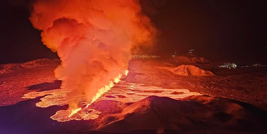
At 05:30 UTC this morning, the intensity of small earthquake activity started northeast of Sýlingarfell. About 30 minutes later, an eruption began in the same area, the Icelandic Met Office (IMO) reports.
For the first few minutes, the crack extended both to the north and to the south.
Based on the first reports from the Coast Guard’s surveillance flight, the eruption is in the same area as the one that erupted on December 18.
The crack is currently about 3 km (1.8 miles) long and runs from Sundhnúk in the south to the eastern end of Stóra-Scógfell.
Lava flows mostly to the west at this stage but appears to be slightly smaller than at the beginning of the eruption on December 18.
The jets reach a height of about 50 – 80 m (165 – 262 feet) and the plume rises to a height of about 3 km (9 800 feet).
The Aviation Color Code was raised to Red.
“Iceland Met Office confirms eruption started near 63.52N 022.25W,” the London VAAC reported at 06:21 UTC. “Eruption is most likely effusive lava, so there will be no further advisories unless ash is confirmed.”
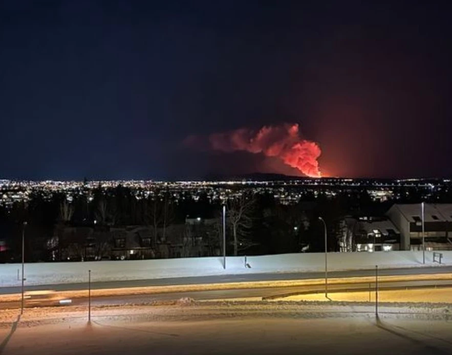
Lava approached the evacuated town of Grindavik, just north of the defense wall that leads to Sýlingarfell, at around 10:00 UTC
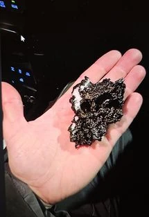
The Norwegian Meteorological Agency has received reports of slag (igneous rock) that has fallen to the ground in Grindavík.
The slag is very flaky and light, and can therefore move considerable distances downwind with a gust of water. The reason that pyroxene is now falling to the ground in Grindavík, 3 – 5 km (1.8 – 3.1 miles) from the eruption, is a combination of the height of the magma plumes, wind direction, thermal flow from the lava bed and low air temperature.
Spectacular drone footage of the lava crossing the road….#Iceland pic.twitter.com/8J87jSVMja
— Volcaholic 🌋 (@volcaholic1) February 8, 2024
The lava has now crossed the road. It’s incredible that we can watch this live!!!
— Volcaholic 🌋 (@volcaholic1) February 8, 2024
Link to livestream below 👇 #Iceland pic.twitter.com/ln7racZbP6
Updates
20:19 UTC, February 8
The vigor of the eruption is decreasing, IMO reported at 17:15 UTC. The eruptive activity is currently in two or three locations on the eruptive fissure. The explosive activity which began between 13:00 and 14:00 UTC is now mostly over, but minor convective clouds rise from some parts of the fissure.
Synchronously with the decreasing vigor of the eruption, the deformation signals detected at the dyke area diminished, indicating that magma is no longer ascending under as much pressure as before.
🔴⚠️🌋🇮🇸New eruption at #Grindavík is ongoing, lava is moving very fast and has already extendede for more than 3km,crossing roads and affecting public infrastructure. Here the latest #Sentinel2 view of Feb.8, where lava is visible while approaching the roads. #Iceland #eruption pic.twitter.com/WSsjKEheUc
— SatWorld (@or_bit_eye) February 8, 2024
Some 12h into the eruption it has almost stopped. https://t.co/CEhkaeKTJX posted a nice overview aerial photo of the lavaflow that cut off access to Blue Lagoon, hot water and power supply to Reykjanes #RUV #eruption #bluelagoon #reykjanes #iceland #svartsengi pic.twitter.com/JKomqzBUAx
— Bart Rijvers 📸 (@BartRijvers) February 8, 2024
Soon after the onset of the eruption, seismic activity decreased significantly and has remained minor thus far. About 20 small earthquakes have been detected over the dyke since 08:00 UTC.
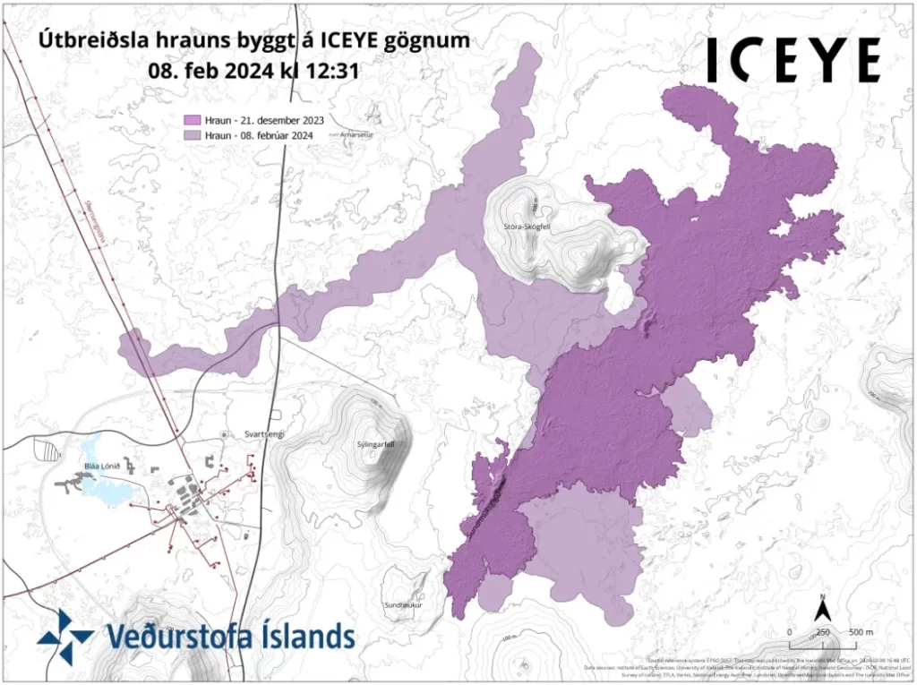
The map shows outlines of the lava flow as it was seen on a satellite image taken at 12:31 UTC. The satellite image shows that lava flowed furthest about 4.5 km (2.8 miles) to the west of the eruptive site.
For comparison, the lava flow field that formed on December 18, 2023, is also shown on the map. Today’s lava flows partly over the lava flow formed in December 2023.
07:54 UTC, February 9
Iceland’s Department of Civil Protection and Emergency Management announced a state of emergency following a volcanic eruption that resulted in lava flowing over and bursting a pipe carrying geothermal water.
This incident has left over 20 000 residents without access to hot water, including Reykjavik’s Keflavik Airport, which, despite losing hot water, continued to operate normally.
The civil protection authority has advised residents in the affected area to limit their use of electric heaters to one per household to prevent power outages. Efforts to restore hot water through an emergency pipeline are underway but are expected to take several days.

Featured image credit: IMO/Björn Oddsson
FYI – The third Video in this article will not ‘load’ on my computer despite several attempts
Yeah, I don’t know what exactly is going on with that video, it should load fine but for some reason it’s not. I replaced it. Thanks!