File:Cape Verde 1746 map.jpg
Jump to navigation
Jump to search

Size of this preview: 779 × 599 pixels. Other resolutions: 312 × 240 pixels | 624 × 480 pixels | 998 × 768 pixels | 1,280 × 985 pixels | 2,560 × 1,970 pixels | 2,662 × 2,048 pixels.
Original file (2,662 × 2,048 pixels, file size: 1.39 MB, MIME type: image/jpeg)
Captions
Captions
Add a one-line explanation of what this file represents
| Description |
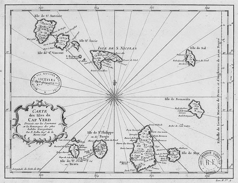
Deutsch: Karte der de:Kapverdische Inseln
English: map of the islands of w:Cape Verde
Français : Carte des isles du fr:Cap Verd |
||||
| Date | |||||
| Source | http://catalogue.bnf.fr/ark:/12148/cb406025638 | ||||
| Author | Jacques Nicolas Bellin (1703-1772) | ||||
| Permission (Reusing this file) |
|
||||
File history
Click on a date/time to view the file as it appeared at that time.
| Date/Time | Thumbnail | Dimensions | User | Comment | |
|---|---|---|---|---|---|
| current | 12:46, 15 November 2012 | | 2,662 × 2,048 (1.39 MB) | Ancalagon (talk | contribs) | better quality |
| 16:39, 1 November 2007 |  | 1,363 × 1,080 (415 KB) | Waldyrious (talk | contribs) | {{Information |Description={{en|map of the islands of Cape Verde}}{{fr|Carte des isles du Cap Verd}} ([http://catalogos.bn.br/scripts/odwp032k.dll?t=xs&pr=fbn_dig_pr&db=fbn_dig&disp=list&sort=off&ss=new&arg=cabo+verde&use=kw_livre&x=0&y=0]) |Source=ht |
You cannot overwrite this file.
File usage on Commons
The following page uses this file:
File usage on other wikis
The following other wikis use this file:
- Usage on cs.wikipedia.org
- Usage on de.wikipedia.org
- Usage on fr.wikipedia.org
- Usage on it.wikipedia.org
- Usage on ja.wikipedia.org
- Usage on no.wikipedia.org
- Usage on pt.wikipedia.org
- Usage on pt.wikibooks.org
- Usage on ru.wikipedia.org
- Usage on www.wikidata.org
- Usage on yo.wikipedia.org